|
"A PRE PRE-RAMBLE"
30 years ago myself and three friends completed the Pennine Way from Edale in Derbyshire to Kirk Yetholm in the Scottish Borders.
The document telling the story of that epic adventure has just come to light.
Written back in 1990 using a Commodore 64 computer and saved to a long-lost 5Ľ" floppy disk this printed draft is the only copy of our story.
As I laboriously re-type the document, I will 'serialise' it on this website in 15 chapters, one for each day of our walk.
So if you are interested, prepare to read on, and on, and on, and on .....
****************************
PRE-RAMBLE
In the beginning was the call,
And the call was from Brian.
"How about joining with me and two or three others walking the Pennine Way next summer?" he asked.
"Yes, why not", I replied, without giving much thought to the suggestion.
So we agreed a date to meet and thrash out the details.
I put the phone down and reached for the Reader's Digest Book of the Road[1]. There I spotted and insignificant green line, occasionally labelled 'Pennine Way', meandering up the backbone of England from Derbyshire to the Scottish Borders. It began in Edale, a place I knew, and ended at Kirk Yetholm, a place I didn't know. I estimated the length to be about 250 miles! What had I let myself in for? A rough calculation and I reckoned this would take at least 18 days. Now I'd done quite a bit of walking but never more than 4 or 5 consecutive days. This would mean averaging 14 miles per day for 18 days!
More research followed prior to our planning meeting. I made my acquaintance with a certain Alfred Wainwright (AW) and his guidebook 'Pennine Way Companion'. Therein AW estimates that allowing for ins and outs, ups and downs, the distance is closer to 270 miles. Thanks AW!
Our meeting took place somewhere in Lincolnshire where the four us met for the first time - Brian, Gwen, Mark, and myself. The first thing to fix were the dates: May 20th to June 3rd 1990. Fifteen days over Spring Bank Holiday weekend, because of work commitments.
Only fifteen days - that's upped the average to 18 miles per day! We would use youth hostels wherever possible and my wife, Ann, and Gwen's (then) husband would provide support for much of the way. By car they would transport luggage onward, search out supplies, and where possible rendezvous with us walkers with tea and cake. (A service which would turn out to be much appreciated by other Pennine walkers!)
So as to get to know each other, and to prepare us for the worst, the four of us agreed to do three walks in the Peak District in February and March. On those days we encountered ice, snow, freezing fog, torrential rain, and sunshine! It just had to be better in May....please!
Notes:
[1]Readers Digest Book of the Road - the definitive Motoring reference and Road Atlas of the 1980s.
****************************
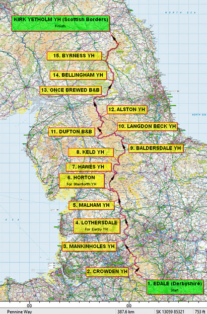
Day 1: Edale to Crowden (15 miles)

"TO REST IS NOT TO CONQUER"
Sunday, May 20th 1990. Edale, Derbyshire. Weather cloudy but bright; no rain forecast.
In fact there had been no rain to speak of for several weeks. The moors were dry and there was a serious fire risk in some parts of the country.
A 9.30am start had been decided. Ann and myself sat in the car waiting for the others and watching the car-park fill up. Cars were disgorging walkers, minibuses disgorging school parties. A continuous procession left their vehicles and headed for the hills sporting a variety of gear; those ready for anything with backpacks, waterproofs, boots and gaiters and others with plastic bags, and wearing t-shirts, jeans, and trainers whilst clutching that other essential item, the 'Walkman'[2].
We sat in the car.
At around 10.15 the others arrived. They had got lost on the journey from Stamford in Lincolnshire to Edale! Was this an omen? Would we become lost on the Pennine moors, never to be seen again [3].
Soon everyone was ready with luggage transferred to 'Sherpa' Ann's car and so an hour later than planned the intrepid foursome set off. But no, Gwen had to visit the loo! So it was at 10.41am precisely on 20th May 1990 we eventually set off from Edale on our great adventure to get to Scotland the hard way.
Brimming with vigour and enthusiasm we strode up the road at a brisk pace passing the official start of the Pennine Way at the Nags Head. We crossed Grinds Brook and followed the badly eroded path towards Grindsbrook Clough[4]. The tourists give up here; only fools continue up the steep, rocky scramble on to the Kinder plateau. Here we became mixed up with t-shirt and trainer brigade who had set off before us. They were finding this scramble hard work, as was I.
Soon we were taking a breather on the plateau. Last time we were here in February, we couldn't see a thing for fog and had to use the compass. Today we could see the featureless plateau, spread out to the north, and again we had to use the compass! We picked our way across the peat hags and groughs [5] but at least the lack of rainfall meant it was dry, and nothing like in the horrendous stories you here about. Eventually the rocks known as Kinder Gates came into view, watching over the sandy bed of the River Kinder. We followed this trickle of water that claims to be a river, but finally it fizzled out completely.
")
Kinder Gates
Kinder Downfall definitely wasn't down-falling, a serious breach of trade descriptions if there ever was? We paused to take in the view from the gritstone crags across Kinder Reservoir towards Hayfield and Glossop.
Having avoided being mugged by the sheep in these parts we continued along the edge of the escarpment to descend on a severely eroded path. Looking back the plateau nature of Kinder Scout is clearly visible.
Now we were faced with a 2˝ mile almost straight, almost level stretch across Featherbed Moss towards Snake Road. Even in these dry conditions it was squelchy underfoot. Various attempts to improve the walking and reduce erosion were breaking up becoming uneven and dangerous. At last a brief firmer section was crossed - the A57 Snake Road. Beyond the road, desolate wastes extended to the appropriately named Bleaklow. There was a chilly easterley wind, but we were thankful it was dry making for comparatively easy going.
From Bleaklow it's all downhill into Longdendale, although finding the way down towards Torside Clough was tedious. The 'Way' follows the edge of the ever-deepening gorge formed by this stream. On Clough Edge, the path is about 300 feet above the stream and the view of Longdendale opens out ahead. We paused on some rocks to survey the scene - Torside Reservoir, Crowden Youth Hostel, a patchwork of fields, with land rising again beyond towards Laddow Rocks and Black Hill.
As we sat, a lone fell-runner headed up the path towards us. As he neared we could see that he was a tall, wiry, elderly gentleman, dressed in just vest and shorts, carrying a small daypack. As he passed, with little sign of breathlessness, he uttered those immortal words 'To Rest is not to Conquer' and disappeared towards Bleaklow. Somewhat speechless we got to our feet and continued our descent into the valley, where we had to veer west to cross the dam of Torside Reservoir. The unsightly pylons still run through the valley, but the railway mentioned by AW, is no more - just an ugly scar defines its course. This may well vanish as there are plans to raise the water-level of the reservoir. Across the dam, a new path through the trees avoided having to walk alongside the busy A628 road. This we had then to cross to access a lane which took us past a campsite to the row of cottages that comprised Crowden Youth Hostel[6]. The time 5.05pm and day one completed - no problem!
The hostel, albeit on the main Sheffield to Manchester road is as remote as any on the Pennine Way, other than Baldersdale, with no major habitation for many miles. At Crowden hostel, we implemented another element of our 'master plan' - volunteering for evening chores (usually washing up) so as not to waste time in the morning[7].
And so to bed. We needed the rest if we were to conquer!
Notes:
[2] A portable cassette tape player for listening to your favourite music whilst on the move (fore-runner of the ipod).
[3] Untrue, or I would not be writing this.
[4] Before the Pennine Way was rerouted via Jacob's Ladder.
[5] Hills and hollows in the peat.
[6] Hostel no longer run by the YHA.
[7] Chores were always a tradition of hostelling to reduce costs, now a thing of the past.
****************************
Day 2: Crowden to Mankinholes (24 miles)

"BRIAN'S DETOUR"
Booking through the YHA effectively determined the distance to be covered each day. With the demise of the Marsden hostel and our ignorance of Globe Farm bunkhouse, 'day 2' was bound to be a tough one! Twenty-four miles that included the crossing of the dreaded Black Hill. Having read of the horrors of this place I had visions of us struggling in ever decreasing circles through bog and fog, never to be seen again [8].
On our way from Crowden by quarter to nine, we gained height steadily above Crowden Brook heading towards Laddow Rocks. The weather was overcast with a strong wind blowing across the moors. I was glad the wind was from the east today; I wouldn't fancy walking along the edge of those cliffs in a strong westerly!
The valley eventually merges into rolling moorland; the marshy grassland giving way to black peat - this was Black Hill. Everywhere was enshrouded in drifting mist. We followed a NE course through this eerie monochrome landscape. Then ahead, the ghostly shape of an OS 'trig' column appeared. Not so much a hill, but definitely black, Black Hill had not lived up to its reputation. Ok it was bleak and inhospitable, but the peat was dry, not the boggy morass of which we had read. In fact it was so dry that the peat appeared to have shrunk and the OS column was perched on a block of concrete about 2ft above ground level. Should OS maps show the spot-height as 1906ft, not 1908ft?
We had found the way across the moor to this point, now we had to find our way off! As we posed for photos at the trig point a figure appeared out of the mist. It was Peter (from Pudsey), a lone Pennine walker who we had met at Crowden. Whilst we argued over compass bearings, Peter remarked that he had done this bit before and confidently strode of into the mist. Quickly we grabbed our packs and set off in pursuit, endeavouring to keep his brightly coloured bobble-hat in view. As we descended the mist cleared and traffic could be seen on the A635 road. Beyond the road stretched more featureless moorland. We crossed the road and trudged onwards - this section across Black Moss and White Moss hold no memories - it all looked the same! A dark sheet of water called Black Moss Reservoir relieved the monotony for a few minutes than it was more moor until another road came into view. The A62 can be seen climbing round Pule Hill out of Yorkshire then disappears into a cutting at Standedge summit before descending into Lancashire. the Way drops down to the road at the west end of the cutting and there in the small car park was the 'Sherpa' car and Ann ready with flasks of tea. Peter was already there taking advantage of the service. He was soon on his way, but not before we'd asked to take our photo. It was now about 12.30pm, so this would be our lunch stop.
")
Rendezvous with 'Sherpa' Ann at Standedge
At 1 o'clock we resumed our trek, having fixed our next check-point as being afternoon tea by the White House Inn, 8 miles on. The walk along the Millstone Edge with good views to the west made a refreshing change from bleak moorland. We made good time along this section; in fact we were going so well we failed to notice a right turning after Northern Rotcher [9] and continued along the Edge eventually reaching the A640 road. It's funny how, when you are 'lost' you can make features on the ground match those on the map. Now we convinced ourselves that the hill ahead was the Rapes Hill on the map, with the route marked by a line of cairns. We scrambled down to the road to find no path, no gate, no sign.... we were wrong. Now we realised that we had deviated too far west and we had no choice to plod up the road to the top of the hill. There as clear as anything was the Pennine Way. Because Brian had the map for this section, he gets the blame and our extra mileage will be forever known as Brian's Detour [10]. So we rejoined the correct path over Rapes Hill.
Now as we topped the hill, a blot on the landscape, the radio masts of Windy Hill, was back in view about 2 miles ahead. With firm ground underfoot we made good progress and soon reached the road by the transmitter. A hot dog van was parked in the shadow of the masts - we wonder whether it was strategically placed to use the microwaves for cooking?

M62 footbridge at Windy Hill
No time for hot-dogs, because of the 'detour' we were running late. A graceful footbridge carries the Pennine Way over the M62 - we paused briefly to watch the traffic thundering underneath. We gladly left the noise of the motorway behind as we crossed more peaty ground on the way to Blackstone Edge. Once again there are views westward over Littleborough. After crossing stony ground the way bears left down a cobbled track, shown on the map as a Roman Road. One section is particularly well preserved, but is thought to be a medieval packhorse road following the line of a Roman road. Whether Roman or medieval, this close encounter with history spurred us, well Brian and Gwen at least, into re-enacting historical scenes - knights in shining armour rescuing damsels in distress! Probably the result of a long day in the sun and the altitude (1,500 ft above sea level).
The Roman road gave way to a concrete road constructed by a water authority, whose presence was to become an all too common feature on these hills. We reached the White Horse Inn on the A58 road at twenty past four. Ann was waiting for us with flasks of tea and scones, with jam & cream. Luckily for us there were no other walkers about!
Soon we were on our way. The next 2 miles is dead flat as the 'Way' keeps to 1250ft contour followed by a water authority road serving Light Hazzles and Warland Reservoirs. It was a sunny afternoon but a cool easterly wind whipped across the waters. Ahead Stoodley Pike came into view. We reached the end of the concrete road and returned to peaty tracks over Langfield Common - much kinder to the feet. Down to the left was the Calder Valley, with the town of Todmorden and the village of Mankinholes with its Youth Hostel. At Withins Gate a flagstone path appeared from over the moor and descended steeply by zig-zags into the valley. This was our way down to Mankinholes. My knees didn't take kindly to this steep descent. Near the bottom of the hill I spotted a stoat looking over a stone wall. No-one else saw it - how could a stoat look over 5ft high wall? Perhaps the long day was getting to me now!
It was ten past six when we reached the hostel. It definitely had been a long day. So it was shower, dinner, pub (at least we were back in civilisation), and bed. Tomorrow was going to be another long day, hopefully without any detours.
Notes:
[8] Again untrue, or I would not be writing this.
[9] A clear sign now shows the divergence of the Oldham Way and the Pennine Way.
[10] We returned the following year to correct this error on a walk from Marsden.
****************************
Day 3: Mankinholes to Lothersdale (22 miles)

"BRONTE COUNTRY"
With legs stiffened by a nights rest, the steep climb back up the flagstone path came as a shock to the system! A fact of this walk would be that just about every day started with a climb. Once on the ridge, we soon arrived at Stoodley Pike Monument[11]. Six of us - the intrepid foursome plus Sherpa Ann and Peter from Pudsey. We were doing the touristy bit at the Monument when suddenly, from out of nowhere, appeared 'Walkie-talkie'. This was the nick-name we'd given to another Pennine walker who we had first encountered at Crowden. Each time we met he would talk non-stop. His accommodation was a motor-home with which he rendezvoused at various places on the route. His days invariable started and finished earlier than ours, and today he had already been walking for two hours. We left him and Ann in the shadow of the Monument and continued our way north. Ann would return to Mankinholes to resume 'Sherpa' duties, although the stroll up and down the hill hadn't done her knees any good!
Today was planned as another 24 miler, but events (or bad planning) brought about a change later in the day. We dropped down off the ridge, through trees back into civilisation - the Calder Valley. And civilisation brings roads & railways, river & canal, and a sewage works! But fortunately all this was soon left behind, as we climbed out of the valley between rows of cottages clinging to the hillside. Down below a train of oil tank wagons rumbled past. At the top we were back to the peace of the countryside. We followed walled lanes and paths alongside fields in glorious sunshine. There was a short steep descent into the little valley of Colden Water, where we took a break on a convenient bench. After Colden village we reached Heptonstall Moor and looking back we could still make out Stoodley Pike through the haze. A head were today's crop of reservoirs with their concrete roads. Once past Walshaw Dean reservoir we entered 'Bronte Country' - the moorland above Haworth, home of the Bronte family[12]. We came upon the ruins of Top Withens, which is thought to be the setting for the Bronte novel 'Wuthering Heights'. It was here that I realised that we were behind schedule. It was now nearly 1 o'clock, which is when we should have met up with Ann at Ponden Reservoir for lunch, but Ponden Reservoir was still two miles away.

Bronte Country - Top Withins
So after just a brief stop at Top Withens, we hurried on down the track into the valley. Several cars were parked near the reservoir dam, but not Ann's. So we plodded on alongside the reservoir until on higher ground near Ponden Hall[13] we spotted 'our car' parked at the far end of the reservoir. What a relief, but it was nearly 2.30 when we finally stopped for our belated lunch.
The dry weather had eliminated the hazard of peat bogs, but the hard ground and reservoir roads were hard on the feet, and I was beginning to suffer from blisters. Therefore I decided to wear trainers for the rest of the day.
Over our late lunch we revised the schedule for the afternoon. The Sherpa taxi pick up point for Earby Youth Hostel would be brought forward from Elslack Moor to Lothersdale. This would reduce today's mileage to 22, but add 2 miles onto tomorrow which was a shorter, 'easier' day. We said farewell to Ann at about 3 o'clock and climbed out of the valley onto Ickornshaw Moor. From up here you could clearly see the dramatic effect of the dry weather on the water level in Ponden Reservoir.
It was about 7 miles to Lothersdale across low moorland, through Ickornshaw village, across farmland and along wooded lanes. We arrived in Lothersdale at about 6.15pm to be greeted by Ann with a bottle of Champagne - well, sparkling wine anyway. This was her response to someone's remark earlier about us deserving a Champagne reception! After drinks we squeezed in the car for the 4 mile drive to Earby hostel, arriving just in time for dinner.
I have few memories of Earby other than that in the hostel, the bunks were so close together it was hard to climb in, let alone fall out! And of course there was the crippling walk to and from the pub!
Notes:
[11] The original Stoodley Pike was built in 1815 to commemorate the defeat of Napolean at the Battle of Waterloo, but it collapsed in 1854. It was rebuilt in 1856 upon declaration of peace at the end of the Crimean War.
[12] Bronte family lived at Haworth Vicarage in first half of the 19th Century. Three sisters became prolific writers of novels, 'Wuthering Heights' being the work of Emily. Their father, Rev Patrick Bronte, outlived his entire family by many years
[13] Emily Bronte is said to have portrayed Ponden Hall as "Thrushcross Grange" the home of the Linton family in "Wuthering Heights".
****************************
Day 4: Lothersdale to Malham (16 miles)

"PASTURES AND BLISTERS"
After two long days, I thought that today would be a pleasant change - mostly at low level through green pastures, by canal and river, with contented cows for company[14] instead of sheep. How wrong can you be!
On a fine Wednesday morning Ann's 'taxi' from Earby returned us to Lothersdale at 9.15. Today we would be walking 16 miles instead of the 14 planned, as a result of yesterday's change, but still less than days 2 and 3 . From Lothersdale there was the usual climb out of the valley to Pinhaw Beacon - which would be the last peat moor for many miles. Down to our left we spotted Peter coming up the direct path from Earby onto Elslack Moor. Ahead was the wide green valley of the River Aire - known as the 'Aire Gap' to all geographers because it provides a way through the hills for road, canal, and railway. In the hazy distance were the limestone hills of Malham.
The peace and tranquillity was briefly interrupted at the crossing of the main A56 road at Thornton-in-Craven. Than on across more fields to join the towpath of the Leeds & Liverpool Canal. We kept to the towpath for about a mile, missing the detour through East Marton village by passing under its unique double-arch bridge[15] which carries the A59 road over the canal. Here we had a close encounter with some bullocks that a farmer was herding along the towpath. Serves us right for not sticking to the 'official' route through the village!

A59 'double bridge' over Leeds & Liverpool Canal
From a small hill called Scalebar we could see our lunch stop, Gargrave, in the valley. Descending through more fields of contented cows to pass under the Leeds - Carlisle railway we emerged in Gargrave near to the Church. In the garden of a pub we ate a leisurely lunch, washed down with a pint of ale. This is more like it - very pleasant indeed... but for one thing - blisters!
On our way by 1.15 we dodged traffic crossing the busy A65, which cuts through the middle of Gargrave. Then, from nowhere came a voice - "Where's the fish and chip shop?" and suddenly there beside us was 'Walky Talky'. Once again he had been on the trail since dawn and had completed is mileage for today. He was now looking for a fish & chip shop and his motor-home. We left him watching boats from the canal bridge.
That afternoon should have been an easy stroll through meadows following the River Aire to Malham. However by now I looked as if I was doing one of Monty Python's[16] 'Silly Walks' as I tried to lessen the pain of my blisters. My silly walk in turn was causing my knees to twinge as I hobbled on often far behind the others. Gwen spotted a kingfisher on the river, but I was too far back, and past caring anyway! They waited for me by the bridge at Hanlith just 1˝ miles from Malham. There a Pennine Way sign directs you away from the river, away from Wainwright's preferred route. The 'official' route climbed quite steeply away from the river - I was not amused! I assume it goes this way to provide a more panoramic view on the approach to Malham with its backdrop of the Cove and limestone hills.
At last, with the blisters bringing tears to my eyes a gratefully slumped onto the grassy bank by Malham Beck. I sat there feeling sorry for myself whilst the others queued for ice-creams. We had done 77miles in four days (only about 200 miles to go!) and I could have given up there and then! I eased my boots off - even my blisters had blisters! We sat in the sun and ate our ice-creams. Gwen examined my feet and pronounced she had never seen blisters that bad. Fortunately, Gwen was an expert in most things, and she had instructed Ann that morning to visit all the chemists in North Yorkshire and stock up on every kind of blister treatment. Tonight there would be the first of Gwen's 'blister clinics'. I wasn't giving up - Gwen wouldn't let me! So at 5 o'clock I hobbled the short distance to the Youth Hostel, to discover that we would be sharing the accommodation with two school parties!
The nearest pub to Malham Youth Hostel is the Listers Arms (shouldn't that be Blisters Arms?) just round the corner. I managed to hobble there in my trainers, with the heels folded down! After a few pints I felt rather better! Tonight we said farewell to Peter from Pudsey. He was moving on at the crack of dawn heading straight through to Hawes by missing out the Horton stop, a distance of about 30miles. By the finish in Kirk Yetholm he would be two days ahead of us.
I must have slept well because I wasn't aware of the boys from the school party coming in after been allowed to stay up late to watch football on TV.
Notes:
[14] 'Contented cows on low green hills' according to AW's Pennine Way Companion.
[15] It would appear the upper arch was built on top of the original bridge to raise it up to the level of the road making it better suited to vehicular traffic.
[16] Monty Python's Flying Circus - a surreal comedy TV series from the 1970s
****************************
Day 5: Malham to Horton-in-Ribblesdale (15 miles)

"THREE DEGREES OF MADNESS"
Gwen was up even earlier this morning as she had promised to see Peter safely on his way to Hawes. After our early morning tea, followed by breakfast, it was time for the first of Gwen's 'blister clinics'. This would be a regular feature from now on for me and Mark. Brian found it all rather amusing, but it transpired that later in our trek he too would be grateful for this service!
Feet well-padded, by 9.30 we were on our way, more than ready for the remaining 193 miles! By 10 o'clock the four of us stood on the top of Malham Cove. Sun, blue skies, white limestone, green grass and no-one else in sight. As they say in these parts - 'it were great'.

On top of Malham Cove panorama
After posing for photos on the limestone pavement we picked our way across the clints and grykes[17] to follow AW's recommended route up Watlowes dry valley. Passing the water sinks, where the outflow from Malham Tarn vanishes into the limestone to emerge at Aire Head springs, we arrived at the road by the Tarn. At the roadside near where the beck passes underneath was a yellow County Council van and a very large brown bull! Both council workmen and the bull were using the beck as their water supply - they all ignored us as we passed. Along the road we rejoined the 'official PW route' and turned north towards the tarn passing more contented cows, and another bull. Below the cliffs of Great Close Scar we entered the nature reserve at Malham Tarn House, originally a shooting lodge, now a Field Study Centre. Skirting round the house the track wends its way to the Arncliffe road. A little way along this road the PW takes the farm road to Tennant Gill and begins the steady climb onto Fountains Fell. Near Tennant Gill Farm one black lamb in a group of white ones attracted Mark to photograph the 'black sheep of the family'.
At the farm the 2 mile drag onto Fountains Fell began in earnest. At around the 2,000ft contour the limestone bedrock gave way to millstone grit, which meant a return to peat hags. The broad summit (around 2,191ft) is rather uninspiring being dotted with cairns, old mineshafts and ruins. The most exciting feature is the view ahead - with the bulk of Penyghent dominating the foreground, Ingleborough to its left and Whernside just visible over its right shoulder - the Yorkshire Three Peaks. After the regulation photo-call we made our way down the steeper north flank of the fell to the road near Dale Head. There we met up with Ann for lunch and that essential flask of tea.
After lunch we continued past Dale Head Farm and at Churn Milk Hole the PW is joined by the 'tourist' and 'Three Peaks' paths from Horton. So on this fine day the climb up the steep flank of Penyghent was very busy. We slowly picked our way upwards around rocks and boulders, children and mums and dads, aunts and uncles. and dogs. Pausing for breath and looking back, I spotted a fell-runner heading up towards us. I stepped to one side and he effortlessly jogged by onwards and upwards. I had only managed a few more steps when I had to step aside again, as another runner came sprinting up the hillside - this time with a bike on his shoulder! As he disappeared over the top, the first runner reappeared, nimbly skipping over the rocks and scree. What with us trekkers, the runner, and biker, there were three degrees of madness on Penyghent that day!
The summit of Penyghent at 2,273ft was the highest point so far for us on the Pennine Way. From the top the path down to Horton is very clear. This section had recently been the subject to much anti-erosion work and the result is the nearest thing to being a motorway for walkers![18] We made good speed down to the gate onto Horton Scar Lane. With time in hand we took a leisurely detour to view two impressive holes in the ground - Hunt Pot and Hull Pot. Then down the lane to Horton-in-Ribblesdale where Ann's car was waiting to run us 4 miles down the dale to the Youth Hostel near Stainforth.
Surprise, surprise we were sharing the hostel with yet another school party, but this time we had our own room rather than a dormitory - we were offered the use of a large 'family' room. At dinner, another surprise - the hostel warden serving the lentil soup was the fell-runner we had seen on Penyghent. He told us that between his duties, he regularly did a quick jog to the summit and back, a round trip of 8 miles with a climb of about 1500ft.!
Notes:
[17] Over millennia, weathering of the limestone creates a 'pavement' of large limestone blocks - 'clints', with gaps between them being known as 'grykes'.
[18] The path down Penyghent, new in 1990, has weathered and now blends into the landscape.
****************************
Day 6: Horton-in-Ribblesdale to Hawes (15 miles)

"TIME GOES BY REAL SLOW"
From today we would be without 'sherpa' assistance for a few days. After dropping us back at Horton, Ann drove through to Hawes with the rest of our gear before heading home. Tomorrow we would be carrying all that as well.... and how would we manage without those cups of tea?
At ten to ten on a bright and breezy Friday morning we said farewell to Ann, then we set off from Horton along Harber Scar Lane. For once there was no steep climb to start the day, but this so-called 'green lane' was a bit rough underfoot. We paused by Sell Gill Holes to watch pot-holers preparing to descend into the depths. The lane then continued along the edge of Ling Gill, an impressive ravine to the ancient bridge over the stream[19]. The essential photo call was made here before continuing onwards and upwards towards the bleaker surroundings of Cam Fell. There may have been no steep climb today but it's a long gradual uphill plod on the old Roman road which stretched straight ahead for 3 miles. Behind us there were views of Ingleborough and Whernside, dwarfing Ribblehead railway viaduct. For about a mile the PW merges with a tarmac road from Cam Houses. The road is left at Kidhow Gate, at 1877ft this is the highest point between Horton and Hawes and a convenient place for a lunch break between the limestone outcrops. From here we got our last glimpse of Yorkshire's Three Peaks. The rest of the day would be all downhill into Wensleydale.

Mark and me at Ten End above Wensleydale
From Kidhow Gate, with its broken signpost just as described by AW in 1967, we followed West Cam Road. This is only a grassy path these days along the 1850ft contour with Dodd Fell on the right and Snaizeholme Beck down in the valley to our left. At Ten End the view along Wensleydale opens out, with Hawes in the valley and the massive bulk of Great Shunner Fell (tomorrow's challenge!) beyond. Ten End is a great spot for photographs so whilst Mark and me busied ourselves with composition, apertures and shutter speeds, Gwen dozed off in the sunshine. Photos taken we were ready to be on our way, but Gwen was fast asleep. It seemed a shame to wake her up, so Brian offered to stay whilst me and Mark continued down to Gayle and Hawes.
The sleepy hamlet of Gayle was also dozing in the afternoon sun. Duerley Beck trickled over its rocky bed down to Hawes, whose church was visible through the arch of Gayle's ancient bridge.

Gayle, with a glimpse of Hawes Church tower through the arch
A group of elderly residents sat by the bridge watching the world go by - the occasional tractor or Land-Rover, or Pennine walker. Mark enquired as to the whereabouts of the ice-cream shop mentioned in AWs guide. Alas, it had long been converted into a holiday cottage, and Mark was subjected to the full story of 'things ain't what they used t'be'. Even so, being in Gayle was like stepping back to an era when 'time passed by real slow'. We departed this sleepy backwater along a path which followed the beck down to the church in Hawes[20].
We emerged from an alleyway and - bang - we were back in the 20th century, with all its hustle and bustle. Hawes is the main market town for upper Wensleydale and attracts many tourists as well as the local dalesfolk. We bought ice-creams and sat and watched all this activity. Still no sign of Brian and Gwen, we did some window-shopping, visited the tourist information, and bought postcards to fritter away the time until the hostel opening at 5 o'clock. When we eventually arrived at the youth hostel, at the top end of the town, Brian and Gwen were not far behind us. Apparently Brian had dozed off as well and other walkers had to step over them as the lay across the path up on the hillside!
At Hawes we became acquainted with other Pennine walkers going our way - notably Alan, a retired Marine from Exeter, and Mel & Maryke, a Dutch couple from Aylesbury. Mel and Maryke were camping/hostelling on alternate days. Today they were camping, but we had agreed to meet them in a pub later.
Today was Friday, the beginning of Spring Bank Holiday weekend and the town was heaving. The pubs were all crowded, and we had to try two or three before finding anywhere to sit - a good excuse for a pub crawl. Then the long plod up through town to reach the hostel by 11 o'clock.
Notes:
[19] Ling Gill Bridge dates from the 17th Century. An inscription on the north wall refers to its repair in 1765 at the charge of the West Riding.
[20] Hawes - famous for its Wensleydale Cheese as in "a nice piece of Wensleydale, Grommit".
****************************
Day 7: Hawes to Keld (15 miles)

"CREAM TEAS & TOURISTS"
Chores done, blistered treated, rucksacks packed - we were on our way by 9.15. Now we were having to carry all our essentials for the next three days, but I soon discovered a 'proper' rucksack even with the bigger load, was far more comfortable than the day-sack I had been using. The rucksack sits higher, on your shoulders, instead of hanging on your back.
We made our way through the town and took the road towards Hardraw across the bridge over the River Ure. (Why is this dale called Wensleydale and note Uredale after the river like the other Dale's dales?). The PW follows a path taking a 'short cut' across fields to meet the road again near the village of Hardraw (or is it Hardrow?). There we caught up with Alan outside the Green Dragon Inn. The pub was open, not for beer, but because it provided access to Hardraw Force, England's highest waterfall[21]. We paid the toll at the bar and walked through the pub to begin our sight-seeing detour. As it was only about 10 o'clock, it was too early for genuine tourists so we had the falls to ourselves. Although the dry weather had reduced the volume of water, it was still pretty impressive, spilling 90ft from the rock overhang into the pool below. We were able to walk right round behind the curtain of water, where Mark took the opportunity of a free cold shower!

Mark takes a cold shower at Hardraw Force
Back in the village we were now faced with the long drag up onto Great Shunner Fell, first along a walled lane then onto the open fell. Four miles up hill would take us from 1,000ft up to over 2,300ft, our highest point so far on this trek. Old tracks branched left and right to long disused coal pits. We caught up with Alan again as he rested on some rocks. Ahead, the great bulk of the Fell seemed to go on forever, whilst behind us, in the haze, was Wensleydale and the hills of yesterday.
After our brief rest we continued onwards and upwards and a last the gradient eased and levelled out and the summit cairn was reached at 2,340ft. Now it was all downhill into Swaledale following a cairned path past evidence of former lead mining to a gate in the 'intake' wall. From here a walled lane leads down to the B6270 road and the little village of Thwaite. Turning left past a row of cottages we came upon the Kearton Restaurant[22] - with a board outside proclaiming 'Afternoon Teas'. Without Sherpa Ann to provide for us, this was an opportunity too good to miss. So soon we were sitting outside in the sun with our cream teas - aye, it were great!

Afternoon cream tea at Thwaite
Then the peace was disturbed by the arrival of Colin and Andy - two more Pennine walkers. They appeared to have noses for beer, and quickly discovered that the restaurant served pints of bitter as well as cream teas! Andy and Colin were from Hexham, in Northumberland, and were kind of walking home via the Pennine Way. Their schedule would more or less match ours for the remainder of our walk. We left them to their pints and set off towards Keld. The path seemed to pass through the garden of a cottage before crossing fields to Kisdon Hill. From here one of the characteristics of Swaledale became clear - just about every stone-walled field had its individual stone barn. There was a grand view down the valley towards Muker, with the hillside meadows carpeted in bluebells. Hereabouts Brian began to have doubts as to whether we were on the correct path - perhaps we should have been further up the hillside? Mark struck off up the hill determined that he would follow the exact route - this was the last we saw of him for some time! We continued to contour round the hill, and soon the path became more distinct along a limestone ledge high above the river. The opposite hillside was dotted with hawthorn bushes in blossom, looking very picturesque in the afternoon sunshine, which I duly captured on film.
The Pennine Way drops down into the valley towards East Gill Force, but that would have to wait until tomorrow. We continued along the lane into Keld past cottages and chapels to arrive at the Youth Hostel - a large sturdy building, overlooking the village. The time was quarter to five, and a considerable crowd had gathered waiting for opening time. Keld is at the crossroads of the Pennine Way and Wainwright's Coast to Coast walk. The latter had become very popular following AW's television series. As well as Pennine walkers and Coast-to-Coasters there were also plenty of weekenders in the queue, it being a bank holiday weekend. There was even a group studying the flora and fauna of the area, but there was no sign of Mark! We checked in and somehow the hostel warden, Peter, found a bed for everyone, even if this meant putting spare mattresses in the corridors! At about 6 o'clock Mark arrived having battled through uncharted territory over Kisdon Hill before deciding to investigate the waterfalls in the valley.
Seven o'clock - time for dinner. As Keld is so remote, with no pub because historically it was a religious non-conformist settlement, there is no choice but to eat at the youth hostel. Peter may have found a bed for everyone, but seating us all in the dining room was a big problem. So to relieve the overcrowding, we volunteered to take our dinner in the member's kitchen. Peter also hadn't allowed for the large crowd with his provisions. This required more improvisation which materialised in the form of 'Keld' pies as an alternative on the menu. We didn't ask what they contained, suffice to say they were prepared in order the make the most of the meagre resources - their meat content was very low!
Keld is situated at the head of Swaledale where the green valley gives way to bleak moorland. This moorland is scarred with mine-workings from the distant past. Once a hive of industry, today only hardy sheep and walkers disturb the remoteness. The hostel warden, in keeping with his philosophy of not letting anyone go cold and hungry, or thirsty, provided a minibus service to the nearest inn, either at Tan Hill or Muker. Tonight's destination was to the Tan Hill Inn, and was so popular that two trips were necessary. Knowing that we would have to walk there tomorrow, I decided not to take advantage of this service[23].
Notes:
[21] Hardraw Force is the highest above-ground waterfall in England - others underground like that at Gaping Gill, which plunges into the 'bowel's of the earth,' have a much greater fall. I believe the entrance fee is now payable at the Camping and Caravan Site behind the Inn.
[22] Kearton Restaurant named after the Kearton brothers of Thwaite, naturalists & wildlife photographers from the early 20th Century. They were the 'David Attenboroughs' of their day.
[23] Keld Youth Hostel was closed in 2008. The building has since been extensively refurbished and re-opened as Keld Lodge Hotel and Restaurant. These days you can eat, drink and sleep in Keld!
****************************
Day 8: Keld to Baldersdale (15 miles)

"I DON'T BELIEVE IT"
There must have been about fifty people at Keld Youth Hostel - walkers, bikers, hikers, botanists, bird-watchers, and photographers. We tried cramming into the dining room for breakfast - we even tried sitting sideways and 'synchronised eating' but to no avail, so we again retired to the members' kitchen. Another couple were already there, obviously realising that was no space in the dining room. They, well she at least, didn't seem pleased at being disturbed by our arrival and gave us a disapproving look. Mark, whose nature it is to strike up a conversation with anyone, anywhere, decided to 'break the ice'. "Walking?" he enquired. "No, photography", was the reply, followed by silence. We continued with breakfast, but Mark was determined. "Photographed any sheep?" he asked. I almost choked on my sausage! There was an agonising pause before the reply. "Well yes actually, in silhouette, contre-jour". Mark's determination wilted - 'contre-jour', there was no answer to that! We finished breakfast as we had started, in silence.
With so many inmates we had failed to do an evening chore. Remember that our plan had been to always volunteer for an evening chore - washing up after dinner - and we had perfected a system of getting this job done quickly and efficiently. This time however, we were allocated washing up after breakfast. Not to worry though, because today our 'team' had eight members as it included Mel & Maryke (the Dutch couple) and Colin & Andy (the lads from Hexham).
But Keld was different.........
50 cups, 50 saucers, 50 cereal bowls, 50 greasy plates, 50 side plates, 50 glasses, 50 sets of cutlery, plus milk jugs, tea pots, greasy frying pans, greasy grill pans, sticky baked bean pan, etc, not forgetting the porridge pan! There may have been eight of us but the space was too small and our system was unworkable. Alan waved us a cheery goodbye (he'd managed an evening chore) as we struggled with the mountain of pots and pans.
At last, at about 10 o'clock we set off from the now deserted hostel, back through the village and rejoining the PW down to where East Gill tumbles over some attractive waterfalls into the River Swale. Time for a few photos before climbing out of the valley past East Stonesdale Farm, from where there is a good view back to the huddle of cottages that is Keld. Once off the farm tracks onto open moor, the going got rough and a bit boggy, particularly where crossing streams. Once over Lad Hill at about 1700ft, Tan Hill Inn was visible about 1 mile ahead in its lonely isolation. It was just past midday when we eventually got there. The Tan Hill Inn is the highest in England, at 1,732ft above sea level. Time for a quick pint before continuing[24].
The day had started bright and sunny, but now it had clouded over and there was a hint of rain in the air. From the back of the inn, the PW heads straight across Sleightholme Moor, coming alongside Frumming Beck before joining a moorland road. The first mile or so turned out to be very squelchy, real bog-trotting country - AW even advises keeping on the road all the way from Tan Hill! But not us - if we're going to complete this walk we'll do it properly - well more or less. Frumming Beck became Sleightholme Beck, an attractive stream through this bleak wilderness. The gloom became drizzle, the drizzle became rain. For the first time since leaving Edale we had to put on our waterproofs. It was lunchtime but with nowhere to shelter we plodded on, joining the road down to Sleightholme Farm. Then rounding a bend, there it was - our lunch shelter. Was it a mirage - an old railway covered wagon 1,400ft above sea level on a bleak Pennine moor?
After our break we continued down past the farm, leaving the road and crossing a field to a bridge over the beck. A scramble up a bank brought us to a wall leading towards Trough Heads. Rough pastures descend to the River Greta about a mile away, and just beyond we could see traffic on the A66 road over Stainmore. We could see our objective but the way to it wasn't at all clear. Stone walls, wire fences, and barbed wire seemed to obstruct our path - why no sign or stile where they are most needed? After some time-wasting too-ing and fro-ing we resorted to climbing over the obstacle of least resistance - a rusty gate held in place by wire and netting. Mission accomplished we made our way down the rough farmland to the River Greta at God's Bridge. This is a natural limestone bridge that has been used as a river crossing for centuries. A pleasant spot for a break, and a bit of geology. The gloomy weather had been left on the moor and the sun was trying to break through.
Photographs taken, it was time to press on. A gate opens onto a lane leading up to the main road. Here we met a gentleman who held the gate open for us. "Have you seen the farmer about?" he asked. We had seen no-one other than fellow walkers. Earlier we had spotted Mel and Maryke about ˝ mile ahead of us, and Alan was not far behind us. "By the way" said the man at the gate, "AW is in my car at the top of the lane". Not believing what I had heard I exclaimed "AW? You mean Wainwright?" We strode up the lane and there sure enough, sitting in the front of the car was the unmistakable figure of AW, stoking his pipe. What an amazing stroke of luck - there we were, about half-way along the Pennine Way bumping into the great man himself. What's more I was clutching his guidebook, the 'Pennine Way Companion'. 'Good day, AW', we said, and in between puffs on his pipe he asked how we were getting on. Up the lane came Alan, looking puzzled as to why we were gathered around a car? Then he spotted the occupant and his eyes lit up. 'Good day, AW', he beamed. On the rear seat of the car sat a lady surrounded by photographic equipment[25]. I asked her if AW might sign his name in my 'Pennine Way Companion'. Appropriately, AW had designated a page for entering names of people you meet. The lady explained that his eye-sight was very poor, but he was prepared to try. She placed the book in front of him, a pen in his hand, positioned the pen on the page and then, rather hesitantly he signed his name. The process was then repeated for Alan. Unfortunately, Gwen had lost her copy of the book, and Brian had left his in Ann's car two days ago. So, with grateful thanks we said farewell. 'Be careful crossing this road' were AW's parting words. We were[26].

AW's signature in my 'Pennine Way Companion'
The noisy intrusion of the A66 trunk road was soon replaced by the peace of Bowes Moor. We walked in silence - well most of us did. There was just the sound of Mark muttering to himself ' I don't believe, I just don't believe it'. We crossed a footbridge over Deepdale Beck and sat down by a wall in the afternoon sunshine, to be joined by Alan. Mark was still muttering 'It's the sort of thing you dream about, I just don't believe it!'. No Mark, it wasn't a dream!

Taking a break near Deepdale Beck
We were now only about 2 miles from Baldersdale Youth Hostel. Here we would face a different challenge - because of its remote location, this hostel is self-catering only! With no support crew, no towns or villages for miles, we would have to rely on provisions from the hostel's 'well-stocked store' for our dinner and breakfast. And so it turned out to be - with tins of this, packets of that, and even frozen foods to cater for all tastes. Gwen rose to the challenge and became a bit carried-away with this self-catering idea. 'I fancy chicken', thought Gwen out loud. 'I've a chicken in the freezer', said Diane, the hostel warden. So chicken it was. In fact our menu turned out to be - soup, followed by roast chicken with new potatoes and vegetables, and a pudding for 'afters'. 'All that's missing is a bottle of wine' someone joked. 'I've a bottle of wine upstairs', replied Diane.
So that was it - the intrepid foursome sat down to a three-course dinner, with wine, to celebrate reaching the half-way point of their adventure.
135 miles from Edale, 135 miles to Kirk Yetholm. 8 days gone, 7 days to go.
I don't believe it!
Notes:
[24] Tan Hill Inn dates to the 17th century, and during the 18th century was used as a hostelry by workers digging coal pits. The building is unusual for its isolation, but it used to be surrounded by miners' cottages. During the 1980s the pub appeared in an advert starring celebrity farmer Ted Moult for Everest double-glazing. Everest returned in 2008 to film a new advert with Craig Doyle and installed new windows and solar panels.
[25] The photographer was Ed Geldard from Kendal. He was working with AW on the book 'Wainwright in the Limestone Dales'. He was hoping to photograph AW on God's Bridge. The book with AW's photograph was published in 1991 shortly after AW had passed away in January of that year. More about this in a postscript at the end of our journey.
[26] The A66 trans-Pennine trunk road is now a dual carriageway and the PW makes use of a farm underpass to negotiate this hazard. We had to dash across a busy 2-lane road in 1990!
END OF PART ONE
****************************
|